Tuesday, August 31, 2010

August Classics


This last weekend I ran the Cutthroat Classic on Saturday, and then bombed down to the Cascade Crest Classic 100 to volunteer/hang out on Saturday night and Sunday. I’m pretty exhausted, and it’s Tuesday. I won’t get much sympathy from those 100 milers, I know. Congrats to all who got out there.

While I did a lot this weekend, hanging with the family is always tops. Camping with Uncle Don and Paul is something I’ve been doing since I was 13, but not in recent years. Many great stories with these guys. We had one legendary trip to the Potholes in Eastern Washington, when Paul and I were teens, where we took no food, declaring to all that we were going to "live off the land."  We were 100% committed to the goal, for a whole week, and quite serious about it. I even remember stopping by Safeway on the way out, because we had to buy aluminum foil for all the fish we were going to bury in the coals of our fire to cook. And I think we picked up a lemon and an onion, for garnish. Things didn’t work out so well.

We met again, Friday night, at Pair-Again Lake outside Winthrop. Very tame, with kids and campfires, the sound of a movie playing on someone's computer. On Saturday morning, Paul’s wife Holley and I got up early, after I had one cooooold night, cowboy camped under the stars, and we caught the school bus to the race start. This was Holley’s third Cutthroat, I think, my fifth. We met my good friend Aaron M. at Rainy Pass, who announced that he’s expecting his next kid. Congrats!

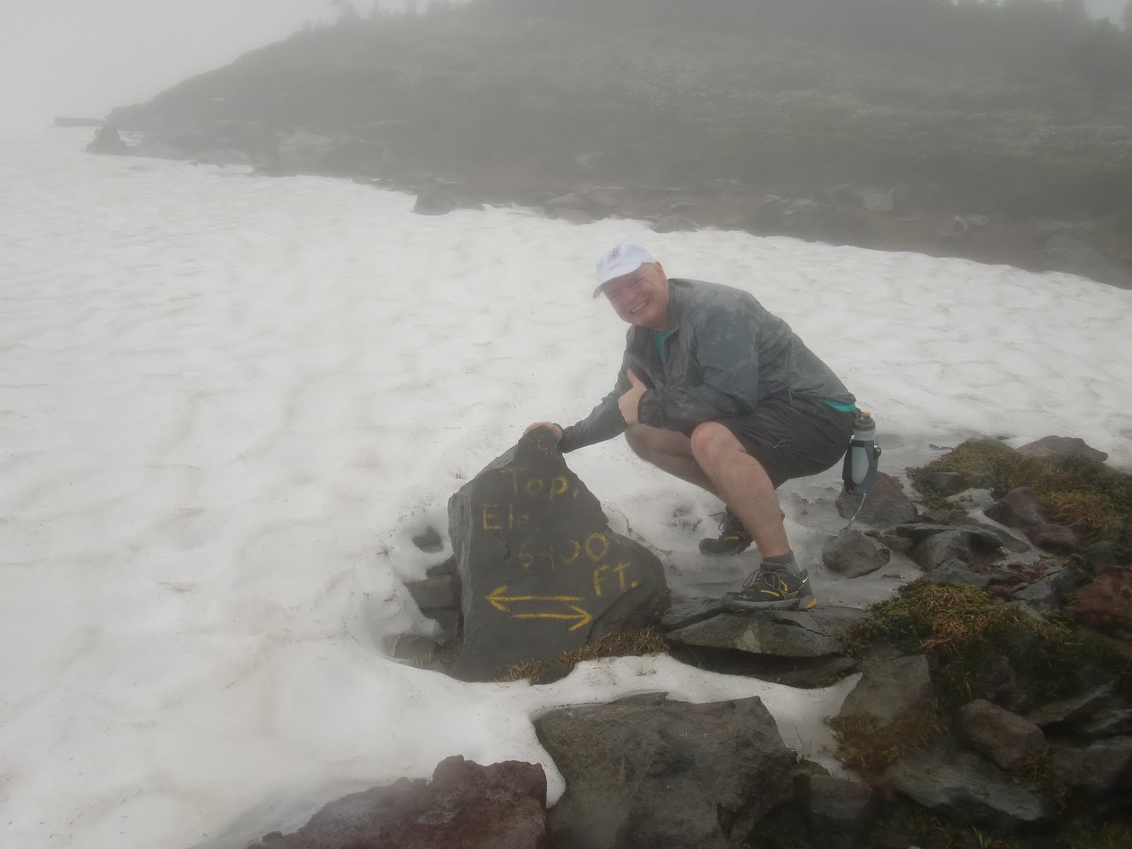
Background:  Cutthroat is an 11.1 mile trail run.  The first five or so miles are on the Pacific Crest Trail, and amount to a beautiful climb up to Cutthroat Pass, first through subalpine forest, and then into the land of rock and ice, though the ice is gone this time of year. The race starts in four different waves, at Rainy Pass, on Highway 20. On the way up, there are gorgeous views looking back towards Maple Pass. Specatators cheer at the top--high point of 6800 feet--and it's a near screamer of a descent, with 6 miles or so of down, through dust and rock, to the finish. On the way down, there's one aid station where the gels and liquids are brought in by horses. It is an absolutely wonderful event, and it sells out every year. Thank you MVSTA and all your great volunteers!

Aaron crushed the course. I did not. I rolled my ankle once, and then again for good measure, and then, to top it off, in the last two miles I honored REM with an “I am superman, and I can do anything!” fall. Just bloods, no breaks. Look for it on failblog. As I said, it’s a dusty downhill—I love it. I was humming GnR’s Dust and Bones and Freefallin', in between falls.

My time was about 10 minutes slower than last time, but it could’ve been worse, and I took a lot of pictures. Clumsy feet, some decline in fitness, but not a complete disaster. The rolled ankle bothers me more than anything--the back was tolerable.

Afterwards, I had a freezing wash-me-up under the bridge (RHCP) in the Methow River, and then it was down south (Alabama) past Chelan to The Race. I dropped B’hamster Heather off at French Cabin, and in the process caught some great semi-Thorpe Mountain type views of Kachess and Rainier, fireweed in the foreground.

Later, I hung out at Hyak (53 m AS), and caught friends Mike and BJ coming through, both running strong. Lots of other great friends to hang out with through the evening, and I was constantly exercising my powers of observation. "So, you're working the aid station?"  "So, you're pacing?" "Hey, doing the race? Cool."

Sunday was Easton all the way, all the day. It never stops being amazing--watching people finish 100 miles, that is. It shouldn’t be. One hundred miles is a long long way, and anyone who can finish the distance is-- amazing. Mike came in way early. BJ finished strong. And I was particularly moved by Dave D.’s finish at the end of the day, with his whole family helping him limp in.

The pics here are of Cutthroat--I'll proably post of a few of Cascade, after a while.

Sunday, August 22, 2010

Sahale Arm


On Saturday, I went up Sahale Arm, off Cascade Pass in the North Cascades, for about 13 miles of trail. The day started with limited expectations. However, due to aesthetic conditions beyond my control, I ended up hiking, sitting, and even strolling more than running, spending the whole day in the mountains. It was an amazing day, with all sorts of wildlife out, and stunning views. 

The big news:  I saw FOUR BEARS! I never see bears, but on Saturday, they were hanging out separately, on steep slopes, just grazing like deer or elk. Three of them were specks, but one was near enough to get a much closer view, and I sat and watched him/her for fifteen minutes. Others reported seeing as many as seven, as well  as a lynx. I saw a few goats near the pass as well.

Hoary marmots and grouse were all over the place. I whistled at the marmots, and they would stand up and look around. A couple of them hung out on this cliff, just looking down towards Pelton Basin. We in my family call grouse "dummy chickens" and nothing I saw on Saturday made me change that tune. I chased one down a trail for at least a 100 yards. All it had to do was leave the trail, but it ran ahead of me on the trail, as if it were terrified. I even found a bear den, or what I think was one—the hole was big enough to cram a few bears in it. It kind of scared me.

My theory is the animals were all out because they need to make preparations for winter. I've heard about this sort of thing on the Discovery Channel.

The high point on the hike/run was 7600 feet, and there was some pretty steep climbing on the arm. I saw one other runner, and he was taking things much more seriously than me, motoring. The campsites at the Sahale Glaicer are rings of stones--there's one in the pic below of me in the foreground, before the sea of mountains. I want to camp there now--the folks I talked to who camped there the night before, under a full moon, called it an experience of a lifetime.

There were clouds in the sky, but everything was visible for ten miles, and that was enough, with Boston Basin, Mt. Johannesburg, Magic Mountain, the triplets and who knows what else viewable. Doubtful Lake is stunning, with an island sitting in the middle. The views to the east, down towards Park Creek and Chelan speak to the imagination. Maybe Labor Day weekend. I saw and even began the Ptarmigan Traverse trail, which is an epic mountaineering experience in the North Cascades.

More pics here.

It was a great day out on the trail, lost in thought, taking pictures, turning corners. I missed out on Waldo, and my congrats to all my friends who did it. It just didn’t sound like a good idea for me this year. Some year, hopefully. My fitness is down, and I can really feel my back when I try to seriously run. I did run steady down from the Pass, and the whole of the day wore me out. I plan on doing Baker Lake as my next 50k, and I’ll have a fun run on Cutthroat Pass in the North Cascades with my family next week, and then volunteer at Cascade Crest.


Sunday, August 15, 2010

Cascade Pass


I told a friend today that with the late arrival of summer, I’ve been almost manic in getting out. I keep telling myself to chill-I need to chill like chilli, be cool. I think I’m going to take a pass on Where’s Waldo, as my running is just not good enough, and I don’t want to drive 7 hours just to have a bad day. I will do the Cutthroat Classic, which I'm sure I can handle. But these are only events. The thing is to be happy, and not let events drive the bus. And quit registering so early.

So, at about 2 PM yesterday, in light of the amazing hot weather, I decided to bolt up to Cascade Pass.

The Cascade Pass trailhead sits at the end of the Cascade River Road, 23 miles east of Marblemount, in the North Cascades National Park. It is a very popular hike, probably the most traveled hike in the park. There are great views of hanging glaciers off Mount Johannesburg, and wildflowers in abundance if the time is right. Cascade Pass is an ancient trail, used by the Upper Skagit tribe, to travel to Eastern Washington. One of these days I am going to launch from here to Stehekin, on Lake Chelan. Could happen next month.

Almost everyone was coming down as I was going up. One of my guidebooks recommends going up after 3 PM, just for this reason. I’d like to say I was following directions, but really, I spent my morning waiting on the cable guy. Bundling now, saving a few dollars, allegedly. 

I didn’t go up to Sahalee Arm, which requires an extra couple miles each way, and some heavy climbing. I'm posting a picture of the distances, just to give any runner friends who come this way an idea or two. I sort of wish I did go up to Sahalee, but the trail to Cascade Pass was rocky, and the road to the trailhead was really winding. I didn’t feel like dealing with both in the dark. Next time, maybe.

I ran some, and hiked fast some. The distance wasn’t enough for me, but no big deal. The climb to Cascade Pass is actually pretty good for running ups, I'd say.

And now today, I got to run with my good friend Breean, over from Spokane! This is very cool for me, as Breean and I used to run every Saturday and do marathons, some years ago now. He and his family are wonderful, and I wish that we saw more of each other.

Breean and I made it our mission to run from Lake Samish to Larrabee Park, or “Samish to Sea,” as I called it. I know the way, through the Land of the Lost, though it's a bit tricky. We made it, although it wasn't any remarkable piece of running, and then we literally went down to the salt water and swam. And then there was more swimming at Lake Samish later, which was just plain awesome, albeit short because I had to get home. With the 90 degree heat we've had this weekend, swimming is the thing to do. It's August.


Sunday, August 8, 2010

Mowich Loop


Rich, Linda and I ran and hiked the Mowich Loop section of the Wonderland Trail on Saturday, in Mount Rainier National Park. As per Rich's wrist technology, the loop was 21 miles with over 7500 feet of climbing. I didn't really run well, in part because of the back but as much because of the time off. It didn't matter--it was good to get out and do something spectacular, after a long week. This qualified. 

Up high, the heather, lupine and paintbrush literally lined the trail, red, blue and red, as if cheering you on. It was about as beautiful a display of wildflowers as I've ever seen. A Bonkers for Botany special.

The weather was not particularly good, with rain through the afternoon, and there were no views of Mt. Rainier, but I didn't really notice, in the moment. Every turn on the trail provided something new and world class, and the company--Rich and Linda--was the best. Many many laughs. And then some.

We started the loop at the Mowich campground. This was Rich's program from the start--I was grateful to be along for the ride.  In the first hour or so, we climbed Tolmie Peak and checked out a lookout, where Forest Service workers were painting and making improvements. I sweated way more than I'd have liked going up, but just went with it.

Back to the Wonderland Trail loop--we descended Ipsut Pass, I think, by monster cliffs and through big tree country. Eventually we ended up down in the Carbon River area, which is a huge washout area--everything  is big in the Rainier area, sort of like Texas. Big rocks, big trees, big glaciers, big creeks. We checked out the Carbon glacier, which I failed to immediately recognize-duh-and then crossed a really long suspension bridge. Lots of friendly backpackers on trail, a few of whom asked, "Didn't we see you at Mowich this morning?"

A long slog up another pass, climbing through a few different ecological zones, including the river valley, up to the mountain streams and fields of flowers, and then to rock, lava, and ice. We ran into some goats in the mist, and they ran away too quick for any good photos. I took lots of photos, but the persistent rain and the camera operator inhibited me from really capturing things. But here's a link to an album I posted.

A long day was completed with nice descent from a pass, through wildflowers, and then a two mile jaunt by Eagle's Roost to Mowich. A really cool loop with the best of people. Just what the doctor ordered for me.


Sunday, August 1, 2010

Buck Creek


I worked the Buck Creek Aid Station on Saturday at the White River 50 miler. I cut watermelon into triangular slices and stacked them on plates. I put peanut butter and jelly on bread slices and cut them into bite size sandwiches. I also sliced Payday bars. It was a fun day!